The anatomy of a tropical cyclone refers to the organized internal structure and physical components that make up one of the most powerful weather systems on Earth. Tropical cyclones are intense rotating storms that develop over warm ocean waters and are driven by heat, moisture, and atmospheric instability. Understanding their anatomy helps explain how these storms form, intensify, maintain strength, and cause widespread impacts such as heavy rainfall, destructive winds, and coastal flooding.
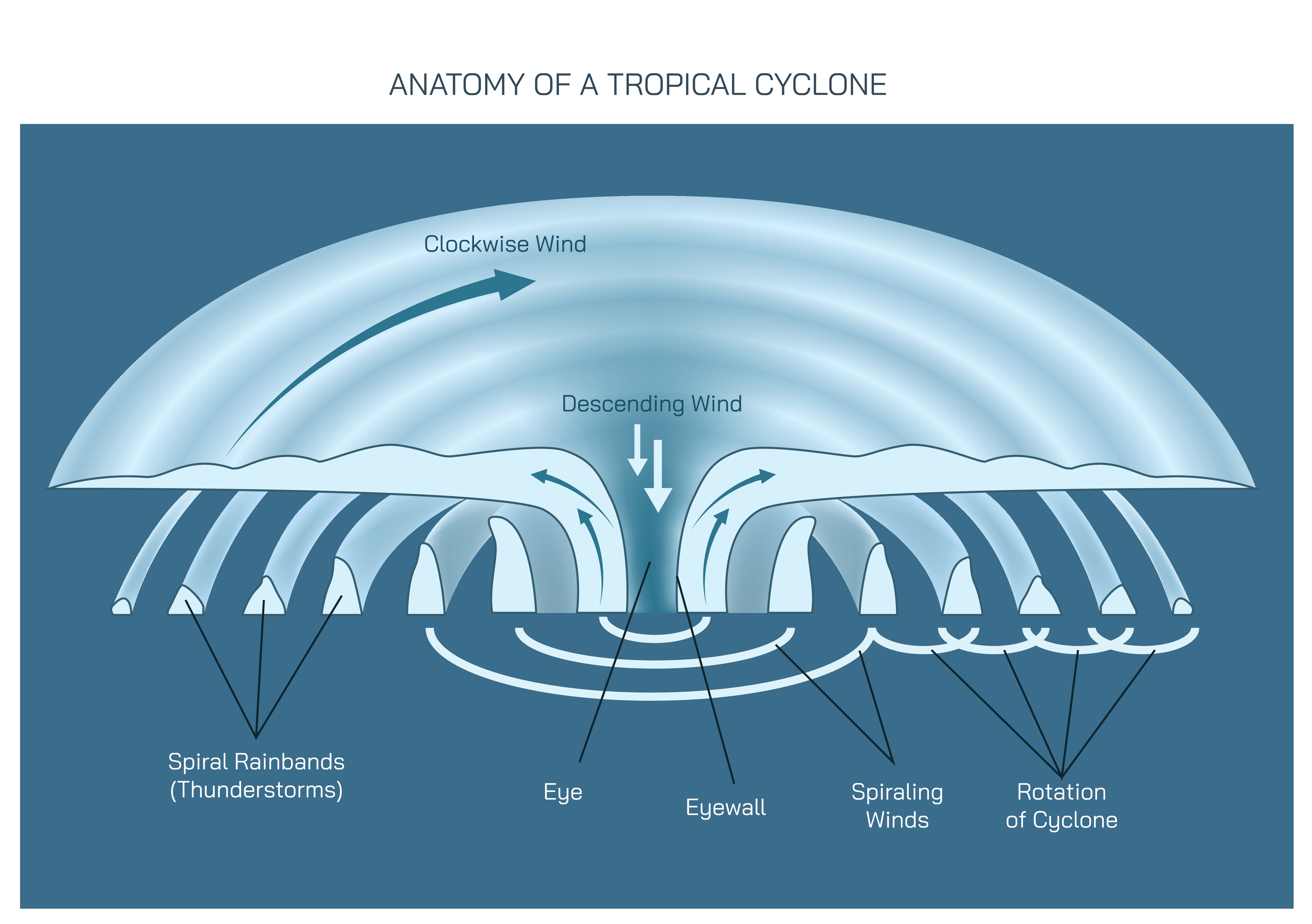
At the center of a tropical cyclone lies the eye, a defining feature of mature storms. The eye is a roughly circular region characterized by relatively calm winds, lighter clouds, and lower rainfall compared to surrounding areas. Despite the overall violence of the storm, the eye can appear deceptively peaceful. This calm exists because air within the eye is slowly descending rather than rising. As it sinks, it warms and dries, suppressing cloud formation. The size of the eye varies between cyclones, and changes in eye diameter can indicate changes in storm intensity.
Surrounding the eye is the eyewall, the most dangerous and energetic part of a tropical cyclone. The eyewall is a dense ring of towering clouds where the strongest winds, heaviest rainfall, and most intense convection occur. Air within the eyewall rises rapidly, fueled by heat and moisture from the warm ocean surface. The steep pressure gradient between the low-pressure eye and the surrounding atmosphere drives violent wind speeds in this region. Eyewall replacement cycles, in which a new eyewall forms outside the original one, can temporarily weaken or later strengthen a cyclone.
Extending outward from the eyewall are spiral rainbands, which are long, curved bands of clouds and thunderstorms that wrap around the storm center. These rainbands can stretch hundreds of kilometers from the cyclone’s core and are responsible for prolonged rainfall, gusty winds, and localized flooding. Rainbands consist of clusters of convective cells that rotate inward toward the center, contributing to the cyclone’s energy and momentum. Weather conditions within rainbands can vary widely, ranging from light rain to severe thunderstorms.
The overall pressure structure of a tropical cyclone is central to its anatomy. Tropical cyclones are warm-core low-pressure systems, meaning the lowest atmospheric pressure is found at the storm’s center. Pressure decreases gradually from the outer edges toward the eye. This pressure difference creates a strong pressure gradient force that accelerates air toward the center. As air moves inward at the surface, it spirals due to Earth’s rotation and then rises within the eyewall.
Wind circulation within a tropical cyclone follows a well-defined pattern. Near the surface, winds flow inward toward the low-pressure center while rotating around it. In the Northern Hemisphere, this rotation is counterclockwise, while in the Southern Hemisphere it is clockwise. At higher altitudes, air flows outward away from the storm center, forming an upper-level outflow. This outflow is crucial for maintaining storm strength, as it removes rising air and allows continued upward motion from below.
The vertical structure of a tropical cyclone reveals how the storm extends through multiple layers of the atmosphere. From the ocean surface to the upper troposphere, the cyclone forms a tall, organized column of rotating air. Warm air rises in the core, while cooler air descends in the surrounding environment. The warm-core nature of the cyclone distinguishes it from mid-latitude storms, which are driven by temperature contrasts between air masses rather than ocean heat.
Ocean heat is the primary energy source of tropical cyclones. Warm sea surface temperatures provide the heat and moisture necessary for sustained convection. As moist air rises within the storm, water vapor condenses into clouds and rain, releasing latent heat. This heat warms the storm’s core, lowering pressure further and strengthening circulation. The continuous release of latent heat acts as the engine that powers the cyclone.
Cloud structure within a tropical cyclone is highly organized. Tall cumulonimbus clouds dominate the eyewall and rainbands, while thinner cloud layers may appear in the eye. These cloud systems extend high into the atmosphere, often reaching the tropopause. Satellite imagery reveals the characteristic spiral shape of cloud bands, which reflects the underlying wind and pressure patterns.
Rainfall distribution in a tropical cyclone is uneven and influenced by storm structure and movement. The heaviest rainfall typically occurs near the eyewall and inner rainbands, but outer rainbands can also produce significant precipitation far from the center. Slow-moving cyclones are especially dangerous because prolonged rainfall can lead to widespread flooding and landslides.
Storm surge is another critical outcome of tropical cyclone anatomy. Strong winds push seawater toward coastlines, while low atmospheric pressure causes sea levels to rise beneath the storm. The combination of wind-driven water and reduced pressure results in storm surge, which can inundate coastal areas. The size and shape of the cyclone, as well as coastal geography, influence the severity of storm surge.
The life cycle of a tropical cyclone is closely tied to its anatomy. The storm begins as a cluster of thunderstorms that organize into a rotating system. As the cyclone strengthens, the eye and eyewall become more defined, and rainbands grow more organized. When environmental conditions remain favorable, the storm can intensify further. However, when a cyclone moves over cooler water or land, its energy supply is cut off, leading to weakening and eventual dissipation.
Environmental factors play a key role in shaping cyclone anatomy. Vertical wind shear, which refers to changes in wind speed or direction with height, can disrupt storm structure by tilting the system and displacing convection. Dry air intrusion can weaken thunderstorms, while interaction with land can break down circulation. Conversely, low wind shear and warm ocean waters promote symmetrical and well-organized cyclone anatomy.
From a scientific perspective, understanding the anatomy of tropical cyclones is essential for accurate forecasting. Meteorologists analyze eye formation, eyewall strength, rainband organization, and upper-level outflow to assess storm intensity and potential impacts. Advances in satellite technology, radar observation, and computer modeling have greatly improved the ability to monitor and predict cyclone behavior.
Beyond the primary structural components, the anatomy of a tropical cyclone also includes subtle internal processes that determine how efficiently the storm can sustain itself. One such process is the continuous exchange of energy between the ocean surface and the lower atmosphere. Strong surface winds increase evaporation, transferring moisture and heat from the sea into the air. This interaction intensifies convection near the storm core and helps maintain the warm-core structure that defines tropical cyclones. When this air–sea interaction weakens, the cyclone’s internal organization begins to deteriorate.
The role of upper-atmospheric conditions is equally important in shaping cyclone anatomy. A well-developed tropical cyclone typically exhibits strong divergence aloft, meaning air spreads outward at high altitudes. This divergence acts like an exhaust system, removing rising air from the storm’s core and preventing pressure buildup. If upper-level outflow becomes restricted due to unfavorable atmospheric patterns, rising air can no longer escape efficiently, leading to weakening of the storm. Thus, even though the cyclone draws its energy from the ocean, its structure depends on the entire depth of the atmosphere.
Another important anatomical feature is asymmetry, especially in cyclones that interact with environmental forces. While idealized tropical cyclones are often depicted as perfectly circular, real storms frequently show uneven distribution of clouds, rainfall, and winds. Wind shear, land interaction, or dry air can cause one side of the storm to become more active than the other. This asymmetry influences where the most severe impacts occur, meaning that the strongest winds and heaviest rainfall are not always evenly spread around the eye.
The inner core of a tropical cyclone is particularly sensitive to structural changes. Small variations in eyewall convection can lead to rapid intensification or sudden weakening. Eyewall replacement cycles are a striking example of internal reorganization. When a secondary eyewall forms, it temporarily disrupts the storm’s structure, reducing peak winds. However, once the outer eyewall contracts and replaces the inner one, the cyclone may grow larger and regain strength. These cycles highlight how dynamic and self-adjusting cyclone anatomy can be.
Thermodynamic processes within the storm also deserve attention. The release of latent heat during condensation does not occur uniformly. Instead, it is concentrated within the eyewall and convective bursts inside rainbands. These bursts can locally lower pressure and accelerate winds, sometimes leading to short-term fluctuations in storm intensity. Such internal variability makes forecasting cyclone behavior particularly challenging, even with advanced technology.
The interaction between a tropical cyclone and land provides another perspective on its anatomy. As the storm makes landfall, friction increases and the inflow of warm, moist air is disrupted. The eyewall begins to weaken, rainbands lose organization, and the eye may fill with clouds. However, even after landfall, remnants of the cyclone can persist as organized systems, producing heavy rainfall far inland. This demonstrates that while ocean heat is essential for maintenance, the storm’s structural framework can survive temporarily without it.
From a hydrological standpoint, the anatomical structure of a tropical cyclone strongly influences flooding potential. The arrangement of rainbands and the speed of storm movement determine how rainfall is distributed over time. Broad, slow-moving cyclones with extensive rainbands are often more dangerous in terms of flooding than compact, fast-moving storms with stronger winds. Understanding this relationship helps explain why some cyclones cause catastrophic floods even when wind damage is limited.
The size of a tropical cyclone is another anatomical characteristic with significant implications. Some cyclones are compact, with intense winds confined close to the eye, while others are expansive, affecting vast ocean and land areas. Larger storms can generate more extensive storm surge and prolonged rainfall, even if their maximum wind speeds are lower. Size, therefore, is as important as intensity when assessing potential impacts.
Advances in observation have revealed fine-scale features within cyclone anatomy that were once poorly understood. Doppler radar, aircraft reconnaissance, and satellite-based instruments now allow scientists to examine wind fields, temperature profiles, and moisture distribution in detail. These observations have shown that tropical cyclones are not static structures but constantly evolving systems, adjusting to internal feedbacks and external influences.
In a broader context, the anatomy of tropical cyclones offers valuable insight into atmospheric physics and energy transfer. These storms represent one of the most efficient natural mechanisms for converting heat energy from the ocean into mechanical energy in the atmosphere. By studying their structure, scientists gain a deeper understanding of convection, fluid dynamics, and climate interactions.
Ultimately, the anatomy of a tropical cyclone is a complex balance of structure, energy, and motion. Every component, from the calm eye to the turbulent rainbands and expansive outflow, contributes to the storm’s behavior and impact. Appreciating these detailed internal processes not only enhances scientific understanding but also supports better forecasting, risk assessment, and preparedness in regions vulnerable to tropical cyclones.
In summary, the anatomy of a tropical cyclone is a complex and highly organized system driven by ocean heat, low pressure, and rotating air. Key components such as the eye, eyewall, spiral rainbands, wind circulation, and vertical structure work together to sustain the storm. This anatomy explains why tropical cyclones can produce extreme winds, heavy rainfall, storm surge, and widespread damage. Understanding these structural elements is crucial for appreciating the power of tropical cyclones and for improving preparedness and response to one of nature’s most formidable weather phenomena.