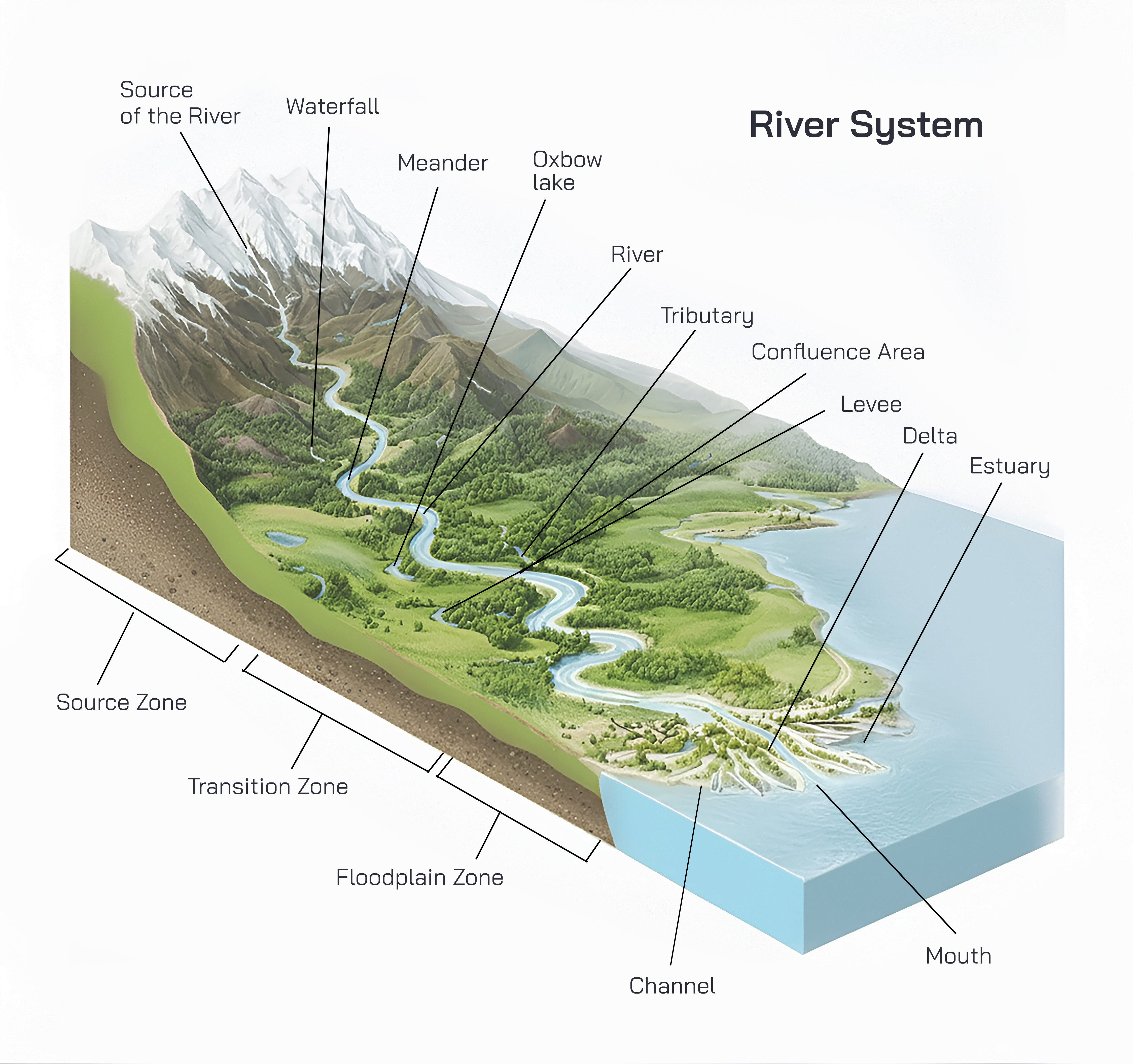
A river system is a natural network of flowing freshwater channels that begins at a source, travels across land through interconnected streams and tributaries, and ultimately drains into a sea, ocean, lake, or inland basin. Rivers are among the most powerful agents shaping the Earth’s surface. Their formation, movement, and interaction with landforms are controlled by gravity, climate, geology, and the hydrological cycle. Understanding how a river is generated from mountain sources and how it flows toward the ocean reveals the dynamic processes that sustain ecosystems, shape landscapes, and support human civilization.
The formation of a river begins at its source, which is the point where flowing water first appears. In mountainous regions, river sources commonly originate from melting glaciers, snowfields, natural springs, or heavy rainfall. High-altitude areas receive precipitation in the form of snow, which accumulates during colder months. As temperatures rise, snow and ice melt gradually, producing a steady supply of freshwater. Gravity pulls this water downhill, causing it to flow along natural slopes and depressions in the land. These initial flows are small and narrow, forming tiny streams known as headwaters.
Headwaters are crucial to river formation because they mark the beginning of surface flow. As water moves downhill, it follows the steepest gradient, cutting into soil and rock through erosion. Over time, repeated flow deepens these channels, allowing more water to accumulate. Multiple headwater streams merge together, increasing the volume and speed of the flow. This merging process gives rise to a recognizable river channel. In mountainous regions, rivers are typically fast-flowing and turbulent due to steep slopes and rocky terrain.
The area of land from which a river collects its water is known as the drainage basin or watershed. Every river system has its own drainage basin, separated from neighboring basins by elevated landforms called watershed divides. Rainfall and melting snow within this basin eventually drain into the main river channel. As water travels across the basin, it gathers sediments, organic matter, and dissolved minerals, contributing to the river’s physical and chemical characteristics.
As the river flows away from its mountainous source, it enters its upper course. In this stage, the river is narrow, deep, and fast-moving. Vertical erosion dominates, meaning the river cuts downward into the bedrock, forming steep valleys, gorges, and V-shaped valleys. Water energy is high, and the river carries large rocks and coarse sediments. Waterfalls and rapids are common features in the upper course due to sudden changes in slope and resistant rock layers.
Moving further downstream, the river enters its middle course, usually characterized by gentler slopes and wider valleys. The river’s speed decreases slightly, and lateral erosion becomes more prominent. Instead of cutting downward, the river begins to erode sideways, widening its channel and valley. Tributaries—smaller rivers or streams—join the main river in this stage, increasing its volume and discharge. These tributaries form a branching network that strengthens the river system and allows it to drain large areas of land.
In the middle course, rivers often develop bends known as meanders. Meanders form because water flows faster on the outer side of a bend, causing erosion, while slower flow on the inner side leads to deposition of sediments. Over time, these bends become more pronounced, creating broad, winding river paths across plains. Floodplains begin to form as sediments are deposited during seasonal flooding, enriching the soil and supporting fertile ecosystems.
As the river continues its journey, it reaches the lower course, where the land is almost flat and close to sea level. Here, the river becomes wide, deep, and slow-moving. Erosion is minimal, and deposition dominates. Fine sediments carried from upstream are deposited along the riverbed and floodplains. The river’s energy is now focused on transporting water rather than eroding land. Floodplains in the lower course are extensive and highly fertile, making them ideal for agriculture and human settlement.
Eventually, the river reaches its mouth, the point where it empties into a sea, ocean, or large lake. At this stage, the river’s velocity decreases sharply, causing sediments to settle. Depending on coastal conditions, the river may form a delta or an estuary. A delta forms when sediment deposition builds up land at the river mouth, creating a fan-shaped network of distributaries. Estuaries form when tidal forces dominate, mixing freshwater with seawater and creating rich, biodiverse environments.
The entire river journey is part of the hydrological cycle, which continuously moves water between the atmosphere, land, and oceans. Water evaporates from oceans and land surfaces, condenses into clouds, and returns as precipitation. Rivers act as the main pathways returning freshwater to the oceans, maintaining global water balance. Without river systems, the redistribution of freshwater across continents would not be possible.
River systems play a vital role in shaping landscapes over geological time. Through erosion, transportation, and deposition, rivers carve valleys, build plains, and create deltas. They influence soil formation, vegetation patterns, and wildlife distribution. Rivers also support diverse aquatic and terrestrial ecosystems, providing habitats for countless species.
For humans, rivers have always been essential. They supply freshwater for drinking, irrigation, and industry. Many ancient civilizations developed along riverbanks due to fertile soils and reliable water sources. Rivers also serve as transportation routes, energy sources, and cultural landmarks. However, human activities such as dam construction, deforestation, and pollution can disrupt natural river systems, affecting their flow and ecological balance.
Rivers are among the most dynamic and influential natural systems on Earth, acting as continuous links between mountains, plains, and oceans. A river system is not just a single flowing channel but a complex network of streams, tributaries, valleys, floodplains, and wetlands that together transport freshwater across continents. The journey of a river from its source at high elevations to its final meeting with the ocean is shaped by gravity, climate, geology, and time. Understanding this journey in depth reveals how rivers sculpt landscapes, regulate ecosystems, and sustain human life.
The birth of a river begins at its source, usually located in high-altitude regions such as mountains, plateaus, or highlands. These areas receive precipitation in the form of rain or snow. In cold regions, snow accumulates over months or years and forms glaciers. When temperatures rise, melting snow and ice release water gradually, ensuring a steady supply even during dry seasons. In other regions, rivers originate from natural springs where groundwater emerges at the surface after percolating through layers of rock. Heavy and continuous rainfall can also generate surface runoff that collects in natural depressions, giving rise to the earliest stream channels.
These initial flows are known as headwaters. Headwaters are typically small, narrow, and fast-moving because they occur on steep slopes. Gravity strongly influences water movement here, causing it to rush downhill with considerable energy. This energy allows the water to erode rocks and soil aggressively, carving narrow channels into the landscape. Over time, repeated erosion deepens these channels, transforming temporary streams into permanent ones. Multiple headwaters gradually merge, increasing the volume of water and forming a recognizable river channel.
The region that supplies water to a river is called its drainage basin or watershed. Every drop of rain or melting snow within this basin eventually finds its way into the river system. Watersheds are separated by elevated ridges or mountain ranges known as divides. The size of a drainage basin plays a crucial role in determining the river’s strength, length, and discharge. Large river systems drain vast areas, collecting water from hundreds or thousands of smaller streams and tributaries, while smaller rivers drain limited regions.
As the river flows away from its source, it enters what is known as the upper course. This stage is dominated by vertical erosion, where the river cuts downward into the Earth’s surface. The river channel here is usually narrow and deep, and the flow is swift and turbulent. Large rocks and coarse sediments are carried along the riverbed, often bouncing and rolling due to the strong current. The landscape in the upper course is rugged, featuring steep valleys, gorges, waterfalls, and rapids. These features reflect the river’s youthful energy and the steep gradient of the terrain.
Further downstream, the river reaches the middle course, where the slope becomes gentler and the river’s behavior begins to change. The speed of the water decreases, and erosion shifts from vertical to lateral. Instead of cutting downward, the river starts eroding sideways, widening its channel and valley. Tributaries join the main river at this stage, significantly increasing its discharge. The merging of tributaries strengthens the river system and allows it to drain a much larger area of land.
In the middle course, one of the most characteristic features to develop is the meander. Meanders are broad bends in the river channel formed by variations in water velocity. On the outer side of a bend, the water flows faster and erodes the bank, while on the inner side, slower-moving water deposits sediments. Over time, these bends become more pronounced and migrate across the floodplain. Floodplains themselves begin to develop as the river overflows its banks during periods of high discharge, depositing fine sediments that enrich the soil.
As the river continues its long journey, it enters the lower course, where the land is almost flat and close to sea level. The river here is wide, deep, and slow-moving. Erosion is minimal because the river has lost much of its energy, and deposition becomes the dominant process. Fine sediments such as silt and clay, carried from upstream, settle along the riverbed and across the floodplain. These deposits make the surrounding land extremely fertile, supporting dense vegetation and extensive agriculture.
Near its end, the river reaches its mouth, where it empties into a sea, ocean, or sometimes a large lake. At this point, the river’s velocity drops sharply, causing it to deposit most of its remaining sediment load. If sediment deposition exceeds the ability of waves and tides to remove it, a delta forms. Deltas are fan-shaped landforms composed of multiple distributary channels that spread the river’s water and sediments over a wide area. In regions where tidal action is strong, an estuary forms instead, creating a partially enclosed coastal body of water where freshwater mixes with seawater. Estuaries are among the most productive ecosystems on Earth.
The flow of a river system is closely tied to the hydrological cycle. Water evaporates from oceans, lakes, and rivers, condenses into clouds, and returns to the land as precipitation. Rivers act as the primary pathways that return freshwater from continents back to the oceans, maintaining global water balance. Seasonal variations in rainfall and snowmelt influence river discharge, leading to floods during wet periods and reduced flow during dry seasons. These natural fluctuations are essential for maintaining healthy river ecosystems.
River systems play a critical role in shaping the Earth’s surface over geological time. Through continuous erosion, transportation, and deposition, rivers carve valleys, form plains, and build deltas. They influence soil development, determine vegetation patterns, and create habitats for countless species. Aquatic organisms depend on river flow for oxygen, nutrients, and migration routes, while terrestrial ecosystems rely on rivers for moisture and fertile soils.
For human societies, rivers have always been central to survival and development. They provide drinking water, support agriculture through irrigation, enable transportation and trade, and generate energy through hydropower. Many of the world’s earliest civilizations emerged along major rivers because of their reliable water supply and fertile floodplains. Even today, river systems remain vital for economic activity, food security, and cultural identity.
However, river systems are sensitive to human interference. Dams, deforestation, pollution, and excessive water extraction can alter natural flow patterns, disrupt ecosystems, and reduce sediment transport. Understanding how rivers naturally originate, flow, and interact with the landscape is essential for managing them sustainably and protecting their ecological and social value.
In essence, a river system represents a continuous journey of water from the highest mountains to the deepest oceans. Beginning as small trickles of meltwater or rainfall, rivers grow stronger as tributaries join, shaping the land and supporting life along their course. Their journey is a powerful reminder of Earth’s interconnected processes, where gravity, climate, and time work together to sustain the planet’s natural balance.
A river system is one of the most complex and long-lasting natural processes operating on the Earth’s surface. It represents a continuous movement of water shaped by gravity, climate, land structure, and time. From the moment water begins to flow at high elevations until it finally merges with the ocean, a river undergoes constant transformation. This transformation is not sudden but gradual, unfolding over thousands to millions of years. Each stage of a river’s journey reflects a balance between erosion, transportation, and deposition, making river systems powerful agents of landscape evolution and life support.
The earliest stage of a river’s life begins high in mountainous or elevated regions where precipitation is greatest. These regions act as natural water collectors. Rainfall that cannot immediately soak into the ground flows over the surface as runoff, following the steepest slopes. In cold regions, snow accumulates over long periods and forms snowfields or glaciers. When temperatures rise, melting snow and ice release water slowly, ensuring a continuous supply. This steady meltwater is especially important because it allows rivers to flow even during dry seasons, maintaining ecological balance downstream.
At first, the flowing water has no defined channel. It spreads thinly across the surface, but as gravity pulls it downhill repeatedly along the same paths, small grooves form in the soil and rock. These grooves deepen over time, developing into rills and then into small streams. These early streams are called headwaters. Headwaters are usually fast, narrow, and highly energetic. Because they flow over steep gradients, their main role is erosion rather than deposition. They cut sharply into the land, breaking rocks and loosening soil particles that will later be carried downstream.
As multiple headwater streams join together, the river grows in size and strength. This joining of streams marks the formation of a river network. The pattern of this network depends on the underlying geology and slope of the land. Some river systems form tree-like branching patterns, while others follow fault lines or resistant rock layers. Regardless of the pattern, all streams within a region contribute water to the main river through the drainage basin. This basin acts like a giant funnel, collecting water from a wide area and directing it toward a single outlet.
In the upper course of a river, erosion is the dominant process. The river has high energy due to steep slopes and gravity-driven flow. Vertical erosion deepens the river channel, creating sharp V-shaped valleys and narrow gorges. Waterfalls often form where there is a sudden drop in elevation or where hard rock overlies softer rock. Over time, waterfalls retreat upstream as erosion continues at their base. Rapids form where uneven rock surfaces disturb the flow, adding to the river’s turbulent nature in this stage.
As the river moves further away from its source, the slope of the land gradually decreases. The river then enters its middle course, where energy is still significant but no longer extreme. Here, the river begins to balance erosion and deposition. Lateral erosion becomes more important than vertical erosion, causing the river to widen its channel and valley. The river now has enough water volume, contributed by tributaries, to transport sediments efficiently over long distances.
Meanders develop prominently in the middle course due to differences in water speed within the channel. Water flows faster on the outer side of bends, eroding the banks, while slower flow on the inner side allows sediments to settle. Over time, these bends migrate across the valley floor, creating wide floodplains. Floodplains are flat, fertile areas formed by repeated deposition of fine sediments during floods. These areas support rich vegetation and have historically attracted human settlements because of their agricultural value.
As the river continues downstream, it reaches the lower course, where the gradient becomes very gentle. The river now flows slowly but carries a large volume of water. Erosion is minimal because the river lacks the energy to cut deeply into the land. Instead, deposition dominates. Fine sediments such as silt and clay settle along the riverbed and across the floodplain. The river channel becomes wider and deeper, and the surrounding landscape is often flat and expansive.
In the lower course, rivers often split into multiple channels as they approach the coast. This occurs because the river loses speed and can no longer carry its sediment load. Sediments are deposited at the mouth of the river, forming deltas if conditions allow. Deltas grow outward into the sea as layers of sediment accumulate over time. In regions where waves and tides are strong, deposited sediments are redistributed, forming estuaries instead of deltas. Estuaries are zones where freshwater mixes with saltwater, creating highly productive ecosystems rich in nutrients.
The entire river journey is closely connected to the hydrological cycle. Rivers serve as the main pathways that return water from land back to the oceans. Evaporation from oceans and land surfaces forms clouds, which release precipitation over continents. This water eventually finds its way back to the sea through river systems. Without rivers, freshwater would remain unevenly distributed, and many ecosystems would collapse.
River systems also influence climate and weather patterns on a regional scale. Large rivers release moisture into the atmosphere through evaporation, contributing to local humidity and rainfall. They moderate temperatures in surrounding areas and support diverse plant and animal life. Aquatic ecosystems within rivers include fish, invertebrates, plants, and microorganisms, all of which depend on flowing water, oxygen, and nutrient exchange.
From a geological perspective, rivers are among the most important agents of landform development. Over millions of years, they carve valleys, transport mountains to the sea in the form of sediment, and reshape continents. Entire plains and deltas are built from material once eroded from distant highlands. This slow but persistent work of rivers demonstrates the power of continuous natural processes.
Human civilizations have always depended on river systems. Rivers provide drinking water, irrigation for crops, fertile soils, transportation routes, and energy. Many ancient civilizations developed along river valleys because of reliable water supply and productive floodplains. Even today, major cities and industries depend heavily on river systems for survival and growth.
However, river systems are fragile. Human activities such as dam construction, pollution, deforestation, mining, and excessive water withdrawal can disrupt natural flow patterns. These disruptions affect sediment transport, aquatic life, and downstream ecosystems. When rivers are altered, deltas shrink, floodplains degrade, and coastal erosion increases. Understanding the natural behavior of river systems is essential for managing them sustainably.
A river system is a living, moving process that connects mountains to oceans. It begins as tiny flows of water, grows through the merging of streams, shapes land through erosion and deposition, supports ecosystems and human life, and finally returns water to the sea. This continuous journey reflects the deep interconnectedness of Earth’s natural systems and highlights the vital role rivers play in maintaining environmental balance and sustaining life on the planet.
In summary, a river system begins high in the mountains where precipitation and melting snow give rise to headwaters. As gravity drives water downhill, streams merge, tributaries join, and the river grows in size and strength. It passes through upper, middle, and lower courses, shaping the land and supporting life along its path. Finally, the river completes its journey by delivering freshwater and sediments to the ocean. This continuous flow connects mountains to seas and plays a fundamental role in sustaining Earth’s natural and human systems.